An Interactive Map of Odysseus’ 10-Year Journey in Homer’s Odyssey
The Odyssey, one of Homer’s two great epics, narrates Odysseus’ long, strange trip home after the Trojan war.
During their ten-year journey, Odysseus and his men had to overcome
divine and natural forces, from battering storms and winds to difficult
encounters with the Cyclops Polyphemus, the cannibalistic
Laestrygones, the witch-goddess Circe and the rest. And they took a most
circuitous route, bouncing all over the Mediterranean, moving first
down to Crete and Tunisia. Next over to Sicily, then off toward Spain,
and back to Greece again.
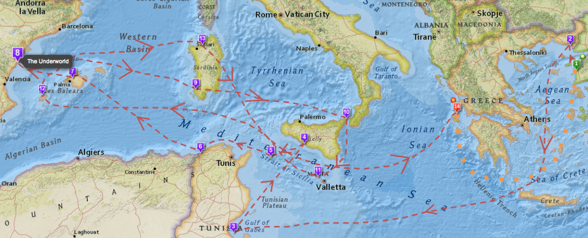
If you’re looking for an easy way to visualize all of the twists and turns in The Odyssey, then we’d recommend spending some time with the interactive map created by Gisèle Mounzer. “Odysseus’ Journey” breaks
down Odysseus’ voyage into 14 key scenes and locates them on a modern
map designed by Esri, a company that creates GIS mapping software.
Meanwhile, if you’re interested in the whole concept of ancient travel, I’d suggest revisiting one of our previous posts: Play Caesar: Travel Ancient Rome with Stanford’s Interactive Map. It tells you all about ORBIS,
a geospatial network model, that lets you simulate journeys in Ancient
Roman. You pick the points of origin and destination for a trip, and
ORBIS will reconstruct the duration and financial cost of making the
ancient journey. Pretty cool stuff.
Copies of Homer’s Odyssey can be found in our of Free Audio Books and Free eBooks collections.
via Paris Review
Related Content:
Hear Homer’s Iliad Read in the Original Ancient Greek
What Ancient Greek Music Sounded Like: Hear a Reconstruction That is ‘100% Accurate’
Discover the “Brazen Bull,” the Ancient Greek Torture Machine That Doubled as a Musical Instrument
Learning Ancient History for Free
No comments :
Post a Comment